Welcome, Guest
Username: Password: Remember me
Non Boat Related, Forum for topics not really having anything to do with boats.

TOPIC: Houston's thread for hurricanes?

Re:Houston's thread for hurricanes? 14 years 6 months ago #9268

  • houston
  • houston's Avatar Topic Author
  • Offline
  • Gold Boarder
  • Gold Boarder
  • Posts: 698
  • Karma: 28
  • Thank you received: 0
well it "lived" all the way up to my expectations, invest 92l died, got caught hanging around some dry air when some when shear showed up and tore it apart...GOOD NEWS for the GULF!

Please Log in or Create an account to join the conversation.

Re:Houston's thread for hurricanes? 14 years 6 months ago #9290

  • houston
  • houston's Avatar Topic Author
  • Offline
  • Gold Boarder
  • Gold Boarder
  • Posts: 698
  • Karma: 28
  • Thank you received: 0
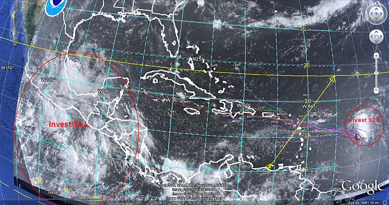
Invest 92 L has pop back up on the plotters, just east of the shear which if it does an "end zone" dive under the shear, just might be able to rebuild it self into a subtropical/tropical depression, after the shear there looks to be a 50/50 chance of either the gulf...or the east coast, I don't know if Ron might be going to another boat show in NJ, but...

let say your out at your mailbox and you look down your street and you see a car coming, it is one thing for it to be coming down the street.

What IF the same car, ends up coming across your back yard and along side your house....and out to where your at.

Off the plot map, but being plotted independently by several different organization (Universities and others) on the 48 hour prediction hurricane forecast is Invest 93 L

the unbelievable scenario which was talked about in the past of "pop up" hurricanes, may seem unreal (at least to me), Invest 93 L is being watched as one, that would add more ciaos to the gulf in a very short period of time, as for a plot on 93 L there isn't on as of yet.
Attachments:

Please Log in or Create an account to join the conversation.

Re:Houston's thread for hurricanes? 14 years 6 months ago #9320

no boat shows till august but i'll be making a trip up to Frank's flat water soon.

Please Log in or Create an account to join the conversation.

Re:Houston's thread for hurricanes? 14 years 6 months ago #9406

  • houston
  • houston's Avatar Topic Author
  • Offline
  • Gold Boarder
  • Gold Boarder
  • Posts: 698
  • Karma: 28
  • Thank you received: 0
hehehe...good news Ron, TAKE SOME VIDEOS...

update one (92L) in the North Atlantic, as of last night it got down graded to a depression, but a side note on this could mean it is trying to get through the shear wind that is trying to tear it apart, but it is putting up a good fight as I see on my last check up it reappeared from a just being a depression, to being a tropical low, which the plots for it have not changed on it's it's possible headings.

little thing that ran through my head last night about the gulf and what remains of 92L is the the storm surge that comes with....any storm. it looks all fine and well with what they are trying to do in the gulf with the man made barriers and booms, booms float but man made barriers don't, so if by design the man made barriers are set for a normal high tide, a storm "surge" would flow over any that was built making them useless. just a little thing that ran around in my head last night.

as for the Pacific's 93L, this one yesterday did a three sisters, where it broke down in to three different invest, which none are posed to threatening the gulf directly, but there is out of the three there is "Tropical Depression Two-E" that should be watched on the west coast, here is one of the links I use, Tropical Weather Tropical Weather [/url]

when 93L broke down in to three different depressions, it should be noted they will not combine back into one big storm, the three "sisters" now will fight for any energy (low fronts) they come across, only the strongest will come out of this.

Please Log in or Create an account to join the conversation.

Re:Houston's thread for hurricanes? 14 years 6 months ago #9437

  • houston
  • houston's Avatar Topic Author
  • Offline
  • Gold Boarder
  • Gold Boarder
  • Posts: 698
  • Karma: 28
  • Thank you received: 0
Invest 92L is back, taking some well know meteorologist off gaurd, frist they said it was "just gonna die", then they said the wind shear would tear it apart...well, 92L looks as if it did the dive under the shear wind and picked up the energy to survive, how? my best guest is the warm water is feeding it.


Now, I gonna tell yea, how this plays out, every time....

what should be going on, but an't someone somewhere should be plotting 92L very soon, but they don't.

even as the plots become narrower, and as 92L grows (which it is as I post) and the land fall points are indicated, no one does anything till it's 24 to 36 hours out, as far as for warnings they all ways say...giving the time they had they did the best they could.

I am just one of the addicts that follow hurricanes from birth till they make land fall, with 92L in a couple of days the ones "in charge" will have plenty of time to see and to react to what 92L does, I tend to hope it well break north to north east but that not looking very favorable at this time, but if it would..it would become nothing more than a shipping hazard and something really nice to look at from above.
Attachments:

Please Log in or Create an account to join the conversation.

Re:Houston's thread for hurricanes? 14 years 6 months ago #9439

  • houston
  • houston's Avatar Topic Author
  • Offline
  • Gold Boarder
  • Gold Boarder
  • Posts: 698
  • Karma: 28
  • Thank you received: 0
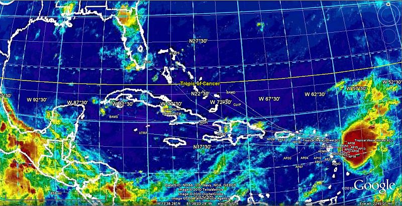
Update....dogs woke me up so I just had to check on 92L.

to my surprise, the storm surge inductions have lite up for possible area that will be effected by 92L (or what ever it will be named).

a La Nina has kicked in, and it looks like the weather "grid" is going to look like it's 1998, historically 98 was a ....very bad year for hurricanes in the gulf.

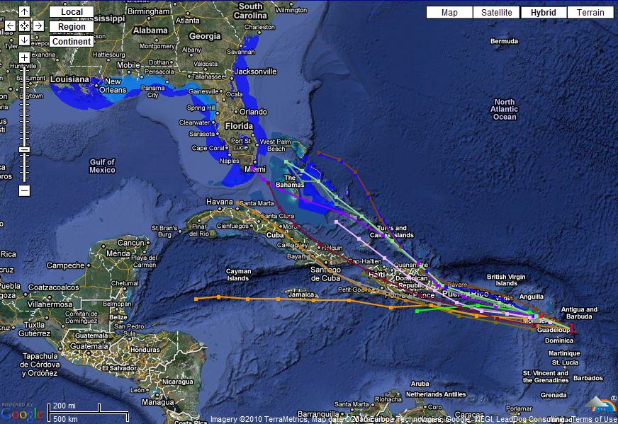
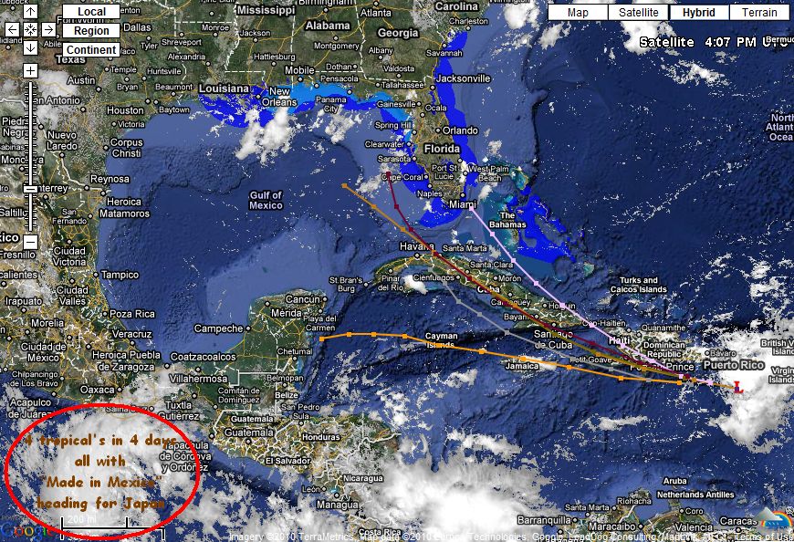
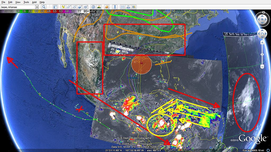
All the lines in the picture above, are plot lines for 92L, each one shows different models possibility's of where the storm may go. in this case each model ends on 6-23-10, giving the consciousness of all the models, I hope by 6-23 someone somewhere will all ready have a plain.

here is what the experts are saying BTW...

For the North Atlantic...Caribbean Sea and the Gulf of Mexico...

A strong tropical wave is expected to move across the Lesser
Antilles today accompanied by a large area of thunderstorms. There
are no signs of a surface circulation and upper-level winds are
forecast to remain unfavorable for development. There is a low
chance...20 percent...of this system becoming a tropical cyclone
during the next 48 hours. Regardless of development...locally heavy
rains and gusty winds are possible over portions of the Lesser
Antilles the Virgin Islands...and Puerto Rico over the next day or
two.

Elsewhere...tropical cyclone formation is not expected during the
next 48 hours.

$$
Forecaster Avila

I am really trying to figure out why they keep d/ling 92L
Attachments:

Please Log in or Create an account to join the conversation.

Re:Houston's thread for hurricanes? 14 years 6 months ago #9491

  • houston
  • houston's Avatar Topic Author
  • Offline
  • Gold Boarder
  • Gold Boarder
  • Posts: 698
  • Karma: 28
  • Thank you received: 0
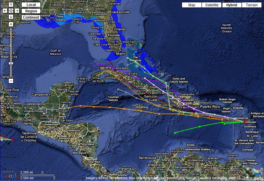
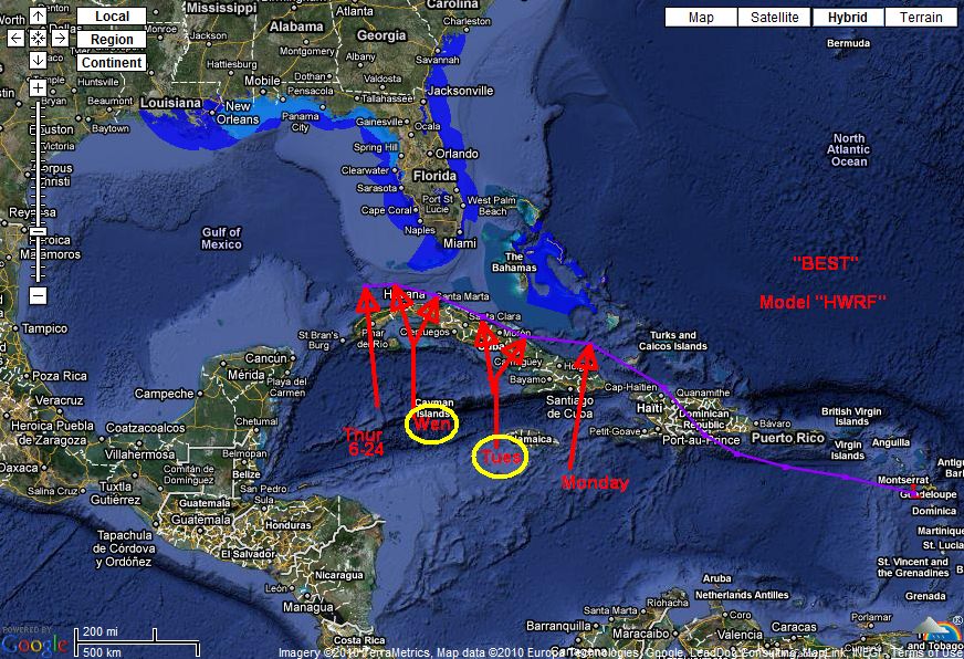
Ok here is how this is playing out, if you look at the past picture things have changed slightly. 92L is going to run south of P.R. and looks as if it going to "hook over, and go just north of Cuba" and across into the Gulf on Monday-Tuesday of next week, all the models are showing this for 6-23 for it to be perfectly between Cuba and the southern tip of Florida with a heading of westward to just north of Havana on Thursday the 24, during this period expectations are 92L will grow into at least a tropical depression/storm by the 23-24 (according to the experts, which said this system was dead 2000 miles ago)

I personally expect the hunters to be scrambled over the weekend for there will be a better plot.

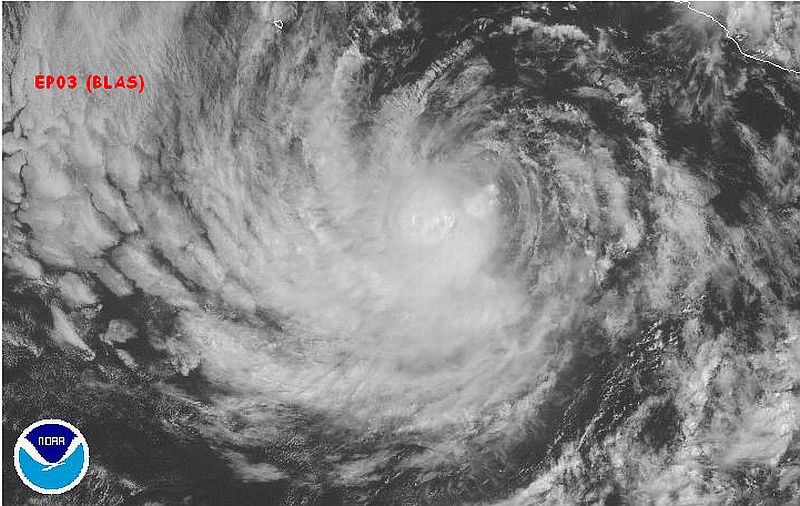
For those on the west coast, an up date on the three sisters, one died of starvation, another is still following her older sister, which really all she is doing is stirring up her wake in to a shear wind that is feeding 92L. her older stronger sister got a name!

Blas...where did they pull that one from?

as for where Blas and her little sister may be going? Japan maybe.

See there is some beauty in them, at least from above.
Attachments:

Please Log in or Create an account to join the conversation.

Re:Houston's thread for hurricanes? 14 years 6 months ago #9526

  • houston
  • houston's Avatar Topic Author
  • Offline
  • Gold Boarder
  • Gold Boarder
  • Posts: 698
  • Karma: 28
  • Thank you received: 0

Ok an update: on 92L it's looking to be in the Gulf considerably now by the 24th.

where this is the 19th, someone alarm system should be blinking...or rotating..or flashing.


there is talk among the addicts that 92L could split in to two tropical depression when it enters the gulf north of Cuba giving the high Cyclone activity just to the west, which then they could develop in to there own Storm with separate tracks, the hunters should be busy with this one.
Attachments:

Please Log in or Create an account to join the conversation.

Re:Houston's thread for hurricanes? 14 years 6 months ago #9529

when its 3days out you'll start seeing some concern.

Please Log in or Create an account to join the conversation.

Re:Houston's thread for hurricanes? 14 years 6 months ago #9570

  • houston
  • houston's Avatar Topic Author
  • Offline
  • Gold Boarder
  • Gold Boarder
  • Posts: 698
  • Karma: 28
  • Thank you received: 0

when its 3days out you'll start seeing some concern.


And that's the problem, even with out the models, using the hunters who can nail the direction and the landfall point days (more than three) ahead of time, when they do, and the storm passes, and the finger pointing starts...you will all ways hear the same thing, there was reasonable warnings that it was going to make landfall..here...

case in point, New Orleans, and Galveston Texas. I sat here in utter disbelief, when they said the only thing they could do was tell people to hunker down in Galveston because up to 24 hours before....they (the local town leaders) where betting on the system to brake to the north and miss them completely,but as we all know...Galveston is still cleaning up, and New Orleans is still rebuilding.

**special Note**
Genny's Step sister works in Houston and lives on the out skirts of Galveston just to the north. For days (more than three) I was telling her to pack it up and leave, she would say I was blowing this storm "out of proportion", the night the storm hit she sent us a text message tell me, "you didn't blow anything out of proportion, all the trees are falling and the house is shaking...been out of power for 4 hours"

Remember the little country called Haiti, that recently had a massive earthquake, guess what in about 24 hours 92L is going to run over them, mind 92(L) is still in it's infancy because it been beating up and abused all the way across the Atlantic, but Haiti will still get a pounding with heavy rains and a moderate 30 mph steady wind. may not sound like much but remember the images from there earthquake, heavy rain will cause massive flooding and the 30 mph wind will be enough to rip apart the tents allot still live in.

after 92L hooks up and around..or over cuba it will no longer be abused by anything, and there is a good chance after Havana it will grow fast, and mean, faster than any one expects, even me.

Please Log in or Create an account to join the conversation.

Re:Houston's thread for hurricanes? 14 years 6 months ago #9580

  • DelRay
  • DelRay's Avatar
  • Offline
  • Expert Boarder
  • Expert Boarder
  • Posts: 272
  • Karma: 10
  • Thank you received: 0
Houston
Keep up the good work! I find this interesting.

Please Log in or Create an account to join the conversation.

Re:Houston's thread for hurricanes? 14 years 6 months ago #9706

  • houston
  • houston's Avatar Topic Author
  • Offline
  • Gold Boarder
  • Gold Boarder
  • Posts: 698
  • Karma: 28
  • Thank you received: 0
Thanks, DelRay...

92L hit a brick-wall of shear wind last night, that pretty well hit it at an angle....pushing down to the south this mourning in the AM. The remains of 92L still "hung" around and I had to see if I could "go-fly" around in it in my FSX program, sure enough I could and what I saw didn't look as if it was gone at all, 8 hours or so later 92L redeveloped "from birth" and was named 93L which still on the same time line and direction that 92L was on, 93L as taken over Looking to be Tropical Storm Alex and in to the Gulf around the 25th

spent the another hour or so seeing if I could fly around Ceil off the west coast central America and...wala, I could and I found out that the hurricane hunters Do Not Get Paid Enough. :X

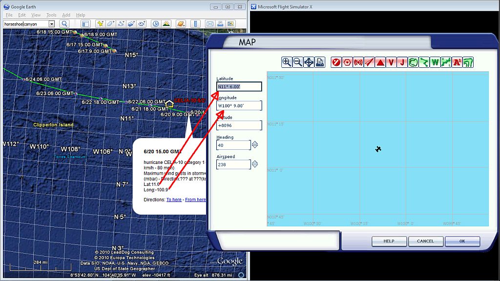
If you have FSX and Google Earth, you can get the Lat/Long of the any hurricane in real time using Google Earth, using that you can pick a plane and set your lat/long and altitude (if you want) for an area you want to fly in. to make it a real jolly great time your going to want to have the weather set to update the simulator every 15 minutes with real world weather.....and off you go to being a flight simulator hurricane hunter!

tell yea all's I would of need was my fan an a mister bottle to make it a bit more "real"

ok so while 93L is getting it grove on, any one ever see the northern lights from outer space?

Nasa just showed this off, it was taking from the space station.
Attachments:

Please Log in or Create an account to join the conversation.

Re:Houston's thread for hurricanes? 14 years 6 months ago #9708

  • DelRay
  • DelRay's Avatar
  • Offline
  • Expert Boarder
  • Expert Boarder
  • Posts: 272
  • Karma: 10
  • Thank you received: 0
Houston,
YES the google earth and the airplane deal. I was hooked on flying for about 6 hours one rainy day here in Kentucky. Heck I flew all over the place and it was a blast!

Please Log in or Create an account to join the conversation.

Re:Houston's thread for hurricanes? 14 years 6 months ago #9709

  • houston
  • houston's Avatar Topic Author
  • Offline
  • Gold Boarder
  • Gold Boarder
  • Posts: 698
  • Karma: 28
  • Thank you received: 0
DelRay, you mean the Flight simulator that is in Google Earth Or Flight Simulator X?

Heck if you mean Flight Simulator X....you can come fly with me on line you know. :laugh:

Please Log in or Create an account to join the conversation.

Re:Houston's thread for hurricanes? 14 years 6 months ago #9722

  • MarkS
  • MarkS's Avatar
  • Offline
  • Moderator
  • Moderator
  • Posts: 5348
  • Karma: 118
  • Thank you received: 5
Hey Mark, Hercules C-130 in your pic? (We worked on "E" models when I was in the Air Force.) Looks like some updated electronics (and avionics I'm sure). Being an assistant crew chief (head mechanic's gofer), I spent a lot of hours sitting on the lower crew bunk watching the flight crew "do their magic", thanks for the flash back! ;)

Please Log in or Create an account to join the conversation.

Mark

Re:Houston's thread for hurricanes? 14 years 6 months ago #9725

  • DelRay
  • DelRay's Avatar
  • Offline
  • Expert Boarder
  • Expert Boarder
  • Posts: 272
  • Karma: 10
  • Thank you received: 0
Houston I was glued to the google flight software for about 6-7 hours that day. I flew over my old farm the current house etc...... Too bad ya can't drop some bombs LOL
Pete

Please Log in or Create an account to join the conversation.

Re:Houston's thread for hurricanes? 14 years 6 months ago #9813

  • houston
  • houston's Avatar Topic Author
  • Offline
  • Gold Boarder
  • Gold Boarder
  • Posts: 698
  • Karma: 28
  • Thank you received: 0
ok update on 93L, looking to have it come in to the gulf as Alex on the 24/25, sad thing from the trajectory "he" will be to the west of the gap of Cuba and Central America making it overly so "easy" for it to get hooked to the north by north east ring in to the pocket of Pensacola, or worse LA.

Ok on to Marks have some flash backs....this won't help matters much but, took off from KROC (Rochester International) Hooked a hard right and then a left out over our bay and came around into the setting sun over the shore line of Lake Ontario before making the last leg back to KROC.

almost picture perfect, till I realized my decent rate was a bit much, with the screen narrowed down it hard to see what the gauges are reading and at the very last minute I could see all this coming down to landing on the take off overrun barrier...so I gave it a hard right rudder and slipped it sideways a little and straighten it out before landing, where you can see the Barrier out the left window going under the wing. so it didn't get counted as a crash but if there where real grounds keepers I am sure I would be getting my.....tore off

Please Log in or Create an account to join the conversation.

Re:Houston's thread for hurricanes? 14 years 6 months ago #9814

  • MarkS
  • MarkS's Avatar
  • Offline
  • Moderator
  • Moderator
  • Posts: 5348
  • Karma: 118
  • Thank you received: 5
Thanks for the ride, H. I could almost smell the JP4!

Please Log in or Create an account to join the conversation.

Mark

Re:Houston's thread for hurricanes? 14 years 6 months ago #9829

  • houston
  • houston's Avatar Topic Author
  • Offline
  • Gold Boarder
  • Gold Boarder
  • Posts: 698
  • Karma: 28
  • Thank you received: 0
well, more of a "update"....93L is kind of waiting to get it's groove on it looks like...as in right now there is very little spin.

MarkS:

This is the model I use in FSX, it is from Captain Sims, you may see your bunk you hung out on.

Please Log in or Create an account to join the conversation.

Re:Houston's thread for hurricanes? 14 years 6 months ago #9846

  • MarkS
  • MarkS's Avatar
  • Offline
  • Moderator
  • Moderator
  • Posts: 5348
  • Karma: 118
  • Thank you received: 5
Thanks H, that was awesome. (The SRV Voodoo Child was a nice touch.) Somebody did went to a lot of effort to make that very accurate, I could almost hear the T-56 Pratt-Whitneys after I yelled "clear number 1" ;) I appreciate it bud!

Please Log in or Create an account to join the conversation.

Mark

Re:Houston's thread for hurricanes? 14 years 6 months ago #9881

  • houston
  • houston's Avatar Topic Author
  • Offline
  • Gold Boarder
  • Gold Boarder
  • Posts: 698
  • Karma: 28
  • Thank you received: 0
my father was a flight engineer---trainer---instructor, on them, so when the "real" simulator wasn't being used, he would get us in to the right seat and let us fly.

sharing the ride online in -X- is fun, I well keep for example #2 running and shut down and feather 1,3,4 and still maneuver and land kind-of hard, but....hearing the wtf from the other four in the plain that are on the ride is priceless....

my farther called the c-130 "a flying tank with out tracks".

Please Log in or Create an account to join the conversation.

Re:Houston's thread for hurricanes? 14 years 6 months ago #9887

  • MarkS
  • MarkS's Avatar
  • Offline
  • Moderator
  • Moderator
  • Posts: 5348
  • Karma: 118
  • Thank you received: 5
I knew they'd fly on two, but ONE!? (Bet that DOES get a little nerve wracking.) Hated hard landings, meant you had to extend the post flight inspection to include pressure checks and such on the main landing gear struts, etc.. (Frequently managed to catch the lg bay door prop rod in back, always came out smelling like burnt rubber, and FILTHY.)

Sorry to sidetrack the thread H, keep up the good work with the hurricane watch... ;)

Squak 127 point niner, contact FG approach on arrival...........

Please Log in or Create an account to join the conversation.

Mark

Re:Houston's thread for hurricanes? 14 years 6 months ago #9976

  • houston
  • houston's Avatar Topic Author
  • Offline
  • Gold Boarder
  • Gold Boarder
  • Posts: 698
  • Karma: 28
  • Thank you received: 0
Ok lets get this back on track, basically 93L formally know as 92L which took a right hook from massive shear winds landing in what is known as "Investigators Canyon", where what was left sprung up 93L the very next day. Like a wobbly prize fighter trying to stand up 93L has been getting back up on his own two feet. the problem is he is stuck.

he has a high front to the north and to the west over Mexico, to his east there is the shear winds that took him out earlier in the week and to his his south west shear wind that is keeping him from going to Hawaii with Celia. There are times I can almost see two grown scientist one in the US...and another somewhere else, the good guy and the bad guy going at each other using the weather. the bad guy spins them up and sends them on their way and the good guy places "blocks" to try to stop it, the problem is the blocks don't last forever they wear out sometimes like the ones 93L is dealing with, looking over his shoulder is a cousin so 93L has to...as the say goes "get it going" or get caught with another system where the stronger can only survive.

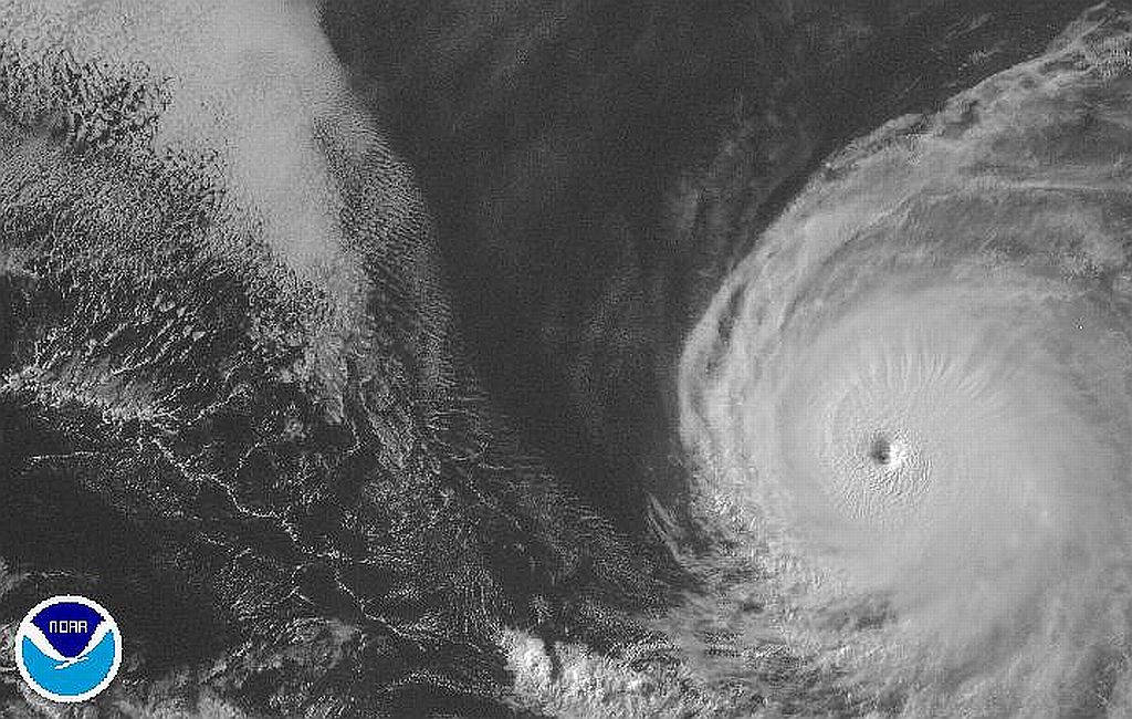
see the little red arrow, that is Celia (your breaking my heart..), she head directly for Hawaii as it is looking right now, and back a little bit if anyone remembers I said "from above they become something that is rather nice to look at" (around those lines I guess) but check out Celia as of this A.M.
more later...
Attachments:

Please Log in or Create an account to join the conversation.

Re:Houston's thread for hurricanes? 14 years 6 months ago #9992

a perfectly formed hurricane.

Please Log in or Create an account to join the conversation.

Re:Houston's thread for hurricanes? 14 years 6 months ago #9999

the coast guard is getting a little jumpy. they say they need 5 days notice to shut down operations and evacuate the gulf. there going to decide by tonite which way to go. if this develops into a tropical depression or worse hurricane, sure hope it stays to the east of the oil, or is it the west?

Please Log in or Create an account to join the conversation.

Re:Houston's thread for hurricanes? 14 years 6 months ago #10000

  • Bigfoot
  • Bigfoot's Avatar
  • Offline
  • Expert Boarder
  • Expert Boarder
  • Posts: 282
  • Karma: 22
  • Thank you received: 0
Just so you know I have been checking on this thread every day since It started. Watch it be the storm of the century and we got to watch it form from a baby, cool stuff. I am hearing about it now on the new's, Mike

Please Log in or Create an account to join the conversation.

Re:Houston's thread for hurricanes? 14 years 6 months ago #10003

its here...tropical depression as of 6:00pm

Please Log in or Create an account to join the conversation.

Re:Houston's thread for hurricanes? 14 years 5 months ago #10031

  • houston
  • houston's Avatar Topic Author
  • Offline
  • Gold Boarder
  • Gold Boarder
  • Posts: 698
  • Karma: 28
  • Thank you received: 0
Man tell yea what a night!

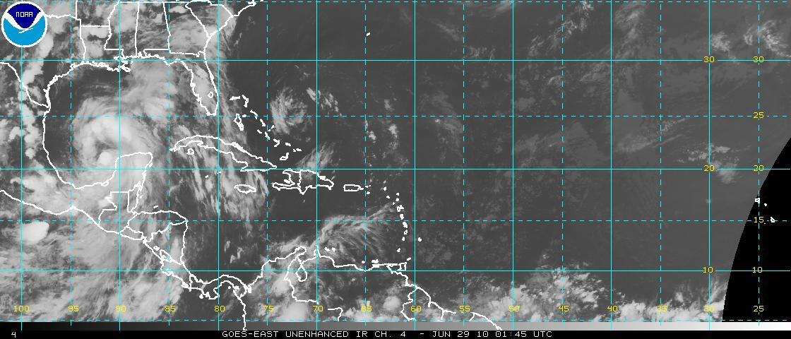
93l went full tilt from being a no nothing problem, to now being a concern to everyone in the Gulf. The NHC (National Hurricane Center) has this heading into the Mexico/Texas boarder as a tropical storm which got a name over night as "Alex".

there are factors that have to be seen that a computer just can't see, one is these beast like warm water, they will turn if they get a half a chance to either avoid land and or go towards warmer water, in this case there is a land mass in his path AND warmer water is toward the northeast up into the pocket in Pensacola, which for all the other models that are running Alex there is over a 50% chance he will turn hard once he get his feet wet in the gulf because of upper level "steering winds" and the fact his little brother came in last night heading for PR and took on the shear winds to his east and drawing off the stationary high that been sitting over the southern states from Texas to Florida.

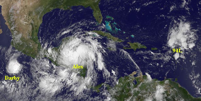
Alex grew so big last night, he doesn't fit in the frame of the Geos hiRes sat picture.

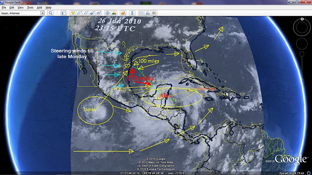
to his west now is Darby-10, which for some reason lost it's barrings and started heading north east towards Mexico City, the other thing they do not like is being together, if a fight for energy is to be had the bigger of the two will all ways win, if Alex consumes Darby-10 as a energy bar, he may be able to go the full 12 rounds. for a better mental picture which I like, will give you a better idea of what I am describing.

as of June 19th this is the oil slick that no one can put in to a mental image...

if alex takes the expected north route and stalls, and hooks to the north west, which is a possibility, the recovery crews could expect 2 to 4 foot swells in the North east pocket which would over flow the any barriers they have had built for "high-tide" with out thinking about high Tide plus 20 feet "just-in-case", if Alex takes an unexpected north east turn in to warm water, all bets are off for the gulf pocket.

if you live in the pocket, the best thing is to just stay informed and have a get out "basket" set up for what you need, I can't stress enough the need for a GPS system to help you stay off the Main Highways, in the past during evacuations everyone drove up to the main highways and sat in bumper to bumper traffic, the ones with the GPS system who stayed down on the 2ed deary roads drove free and clear spending as much time driving to their destination as they would normally....minus the time they stop for lunch....and the gift shop and the tourist look out areas, which if they where up on the main highway...all they would see would be a endless line of brake lights.
Attachments:

Please Log in or Create an account to join the conversation.

Re:Houston's thread for hurricanes? 14 years 5 months ago #10043

  • houston
  • houston's Avatar Topic Author
  • Offline
  • Gold Boarder
  • Gold Boarder
  • Posts: 698
  • Karma: 28
  • Thank you received: 0
I completely missed deray post about flying over his house in Google's flight simulator.

if you use FSX, you can do what you wish for...well they are flour bombs but it is still fun.

The other "fun" thing is to put in the N lat and the west Long coordinates in to it and fly your "model" in to the monsters!
Attachments:

Please Log in or Create an account to join the conversation.

Re:Houston's thread for hurricanes? 14 years 5 months ago #10105

  • houston
  • houston's Avatar Topic Author
  • Offline
  • Gold Boarder
  • Gold Boarder
  • Posts: 698
  • Karma: 28
  • Thank you received: 0
----Alex is heading WEST!----

as it looks right now he will jump the Yucatan go into the south west pocket of the gulf, and continue west across Mexico...which he just may cross, which would make him a west cost problem....this could be interesting.

Please Log in or Create an account to join the conversation.

Re:Houston's thread for hurricanes? 14 years 5 months ago #10113

  • houston
  • houston's Avatar Topic Author
  • Offline
  • Gold Boarder
  • Gold Boarder
  • Posts: 698
  • Karma: 28
  • Thank you received: 0
Did I say interesting about an hour ago, ok I was in a rush, had a great game of Black Jack going, then we started hearing the local fireworks...and well i guess it gave me time to think and to reflect and ask my self, when was the last time I ever took what the NHC had to say to the bank....-never-.

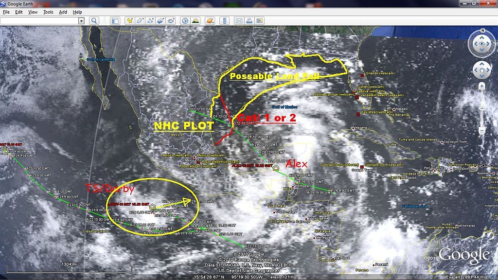
what I wrote earlier was after I read the NHC debriefing for Alex, which after thinking about it I really had this strange feeling about a hurricane that was named Ivan that just would not leave the gulf or Florida alone for a minute One day it was a hurricane...next it was a tropical depression flooding Florida east to wast as it headed across it just to turn back around an become a hurricane again just to run BACK across Florida again. it really became what the navy refers to as a "crazy Ivan" as seen in the movie "the hunt for the Red October". during all of this the NHC was only calling Ivan when it would make land fall and then only if it was a tropical storm or greater, not as a tropical depression or any thing lesser than which there are several steps below that each storm has to achieve in order to become a hurricane with is what the NHC is "all about" and I would like to add there are many sites that forecast hurricanes that after a while you can feel all of them out to see who is blowing the most out of any storm by which way the cards fall. One man I follow that I like how he lays it all out is Dr. Jeff Masters who did his time as a hunter and he really takes everything into consideration, the one thing I do respect that he does is he has this whoa, lets wait and see what this turns into in the AM, or on Monday.

Now Alex is going to cross the Yucatan peninsula then head north west across the lower pocket of the gulf of Mexico (575 miles) during this time Alex well have time to regain himself and if possible swallow his nice energy bar "Darby", of that 573 miles Alex will transverse the last 100 miles, here is where he will have the opportunity to grow in to a full scale hurricane, which should happen over the next 30 hours or so.

what is expected....to happen is for Alex to go ashore at the Texas/ Mexico Boarder and as the NHC has it, Alex will be written off there as -done-

ok working with the above scenario, lets say Alex grand stands into a category 2 hurricane and it does hit right at the boarder, this would leave Galveston in the N/E quad of the bands of Alex, if you look at an old school clock, between 12 and 3 would be considered the N/E quad of a hurricane that has the higher amount of winds then the rest of the storm, ...I haven't heard anything being said to Galveston about this nor do I see them posting High wind hurricane warning flags along the Texas shore line in the "zone" either, Florida, and Mexico..yes, Texas sadly, no.

come late Monday early Tuesday, Alex could do two things, die as expected, or stay off the Texas coast and change course using the steer winds and head east building up as he moves along the coast line.

come late tuesday we should really know about Alex, but the longer Alex stays out in gulf the more rough the gulf will become for the people working on the oil recovery.
Attachments:

Please Log in or Create an account to join the conversation.

Re:Houston's thread for hurricanes? 14 years 5 months ago #10143

  • houston
  • houston's Avatar Topic Author
  • Offline
  • Gold Boarder
  • Gold Boarder
  • Posts: 698
  • Karma: 28
  • Thank you received: 0
well 15 hours ago I had a feeling that Alex would stir up the pot a little, and of course it sure is looking as if he might. Alex Is hold his North West course across the Yucatan peninsula, but everything that was in the NHC favor of him just landing at the boarder and dieing is changing. One of the important things to keep in mind if the NHC plot does work out Alex would turn in to a Subtropical storm that would end up running across the top of the gulf coast, and everyone on the east coast knows what a subtropical storm is all about, heavy rains, flooding with a side of winds that make you hold on to the steering wheel with white knuckles.

most of the models are now showing after alex grows in to a Cat 1 or 2 hurricane he will have 40% chance of turning to the north east to east along the coast of the gulf, which if he does he would grow as he heads in to warmer water.

more in a bit.
Attachments:

Please Log in or Create an account to join the conversation.

Re:Houston's thread for hurricanes? 14 years 5 months ago #10145

geraldo says its heading into mexico. :whistle:

Please Log in or Create an account to join the conversation.

Re:Houston's thread for hurricanes? 14 years 5 months ago #10149

  • houston
  • houston's Avatar Topic Author
  • Offline
  • Gold Boarder
  • Gold Boarder
  • Posts: 698
  • Karma: 28
  • Thank you received: 0
oh really, and geraldo is the same guy that said there was money in the vault...yea, well there is now a 50% chance Alex is going to either make it to a cat 1 or 2 and stall before making land fall at the boarder, or turning North East by East along the coast Monday in to Tuesday.

If Alex does run to shore, the remains of Alex would become subtropical and head east, there also has been a surge in the gulf tides and current because of Alex on the North-west pocket that will continue up in to New Orleans area that will then shift towards Galveston and then head back across the gulf toward Florida later in the week, hurricane Alex or subtropical Alex will not be very welcomed in the Northeast pocket of the Gulf.

Please Log in or Create an account to join the conversation.

Re:Houston's thread for hurricanes? 14 years 5 months ago #10217

  • houston
  • houston's Avatar Topic Author
  • Offline
  • Gold Boarder
  • Gold Boarder
  • Posts: 698
  • Karma: 28
  • Thank you received: 0
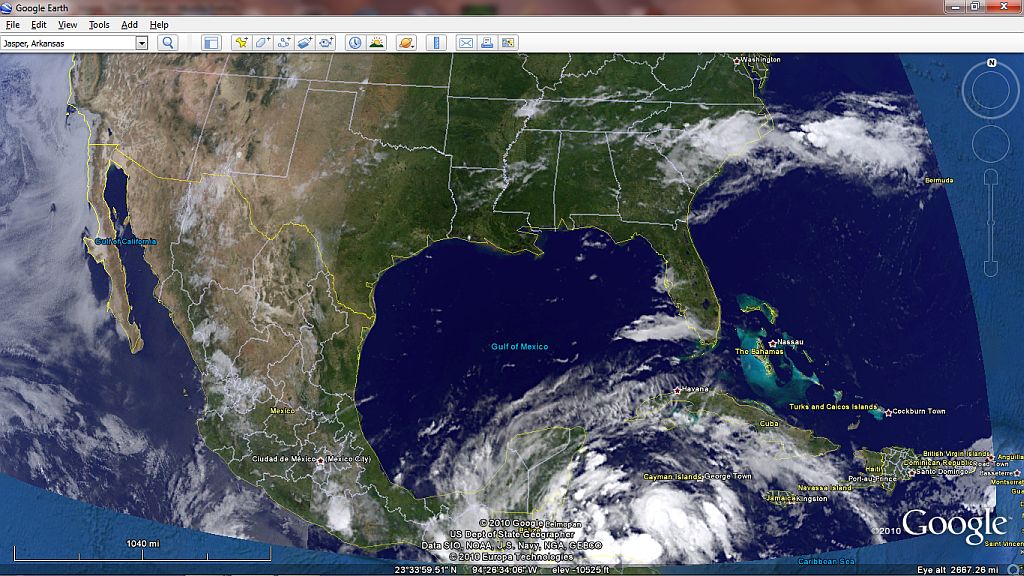
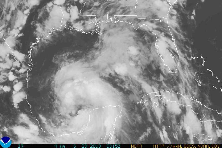
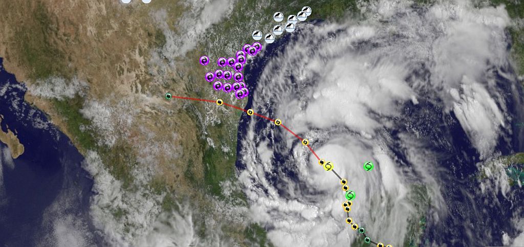
figured I give some a little "Eye candy", excuse the pun....unlike what geraldo has said there is a remarkable high chance of this staying on it north track longer before it takes a North by North West turn into the likelihood of south west of Galveston as a high Cat 2 ...or a low Cat 3.

position is, N20◊30' by W91◊47'

oh ...se what I mean about "Eye Candy :lol: "?
Attachments:

Please Log in or Create an account to join the conversation.

Re:Houston's thread for hurricanes? 14 years 5 months ago #10226

  • houston
  • houston's Avatar Topic Author
  • Offline
  • Gold Boarder
  • Gold Boarder
  • Posts: 698
  • Karma: 28
  • Thank you received: 0
OK here the official...read, about Alex and I am not making it up, so if you live on the coast of Texas, I will say just about...anywhere (like I said a couple of days ago in on of my pictures....from the Texas boarder coast line all the way up....and across, may be effect

to help some who get a trad short on long reads, I will bold up some key point of this advisory.

WTNT41 KNHC 290248
TCDAT1
TROPICAL STORM ALEX DISCUSSION NUMBER 14
NWS TPC/NATIONAL HURRICANE CENTER MIAMI FL AL012010
1000 PM CDT MON JUN 28 2010

ALTHOUGH THE SATELLITE PRESENTATION OF ALEX CONTINUES TO BE A LITTLE
RAGGED-LOOKING...DATA FROM THE AIR FORCE HURRICANE HUNTERS INDICATE
THAT THE STORM IS GRADUALLY STRENGTHENING
. PEAK 925 MB FLIGHT-LEVEL
WINDS WERE 68 KT AND MAXIMUM SFMR-MEASURED WINDS WERE 53 KT.
AIRCRAFT OBSERVATIONS ALSO SHOWED THAT THE MINIMUM CENTRAL PRESSURE
HAS DROPPED TO 985 MB...A RATHER LOW VALUE FOR A TROPICAL STORM.
BASED ON THE WIND MEASUREMENTS...THE INITIAL INTENSITY IS SET TO 55
KT FOR THIS ADVISORY.

CENTER FIXES FROM THE RECONNAISSANCE AIRCRAFT INDICATE THAT THE
STORM HAS DRIFTED MOSTLY NORTHWARD OVER THE PAST SEVERAL HOURS
...AND
THE INITIAL MOTION ESTIMATE IS 360/4. THIS MOTION IS BELIEVED TO
BE TEMPORARY BECAUSE THE GLOBAL MODELS ARE FORECASTING A MID-LEVEL
RIDGE TO BUILD TO THE NORTH OF ALEX OVER THE NEXT COUPLE OF
DAYS...WHICH SHOULD INDUCE A GRADUAL BEND OF THE TRACK TO THE LEFT.
THE TRACK MODEL CONSENSUS HAS SHIFTED ABOUT A HALF DEGREE TO THE
NORTH DUE TO THE RECENT NORTHWARD MOTION...AND THE OFFICIAL
FORECAST IS ADJUSTED SLIGHTLY NORTHWARD AS WELL. ONE SHOULD NOT
FOCUS ON THE EXACT LANDFALL POINT...HOWEVER...SINCE THE AVERAGE
TRACK FORECAST ERROR IN THE 48- TO 72-HOUR TIME FRAME IS 100-150
NAUTICAL MILES.
...(note that error possibility)

THE WESTERLY SHEAR THAT WAS AFFECTING ALEX HAS ABATED AND THE SHIPS
MODEL DIAGNOSES A FURTHER DECREASE IN SHEAR...TO BELOW 10 KT IN 24
HOURS. AS ALEX MOVES AWAY FROM THE SHELF WATERS NEAR THE NORTHWEST
COAST OF THE YUCATAN...IT SHOULD PASS OVER WARMER SEA SURFACE
TEMPERATURES DURING THE NEXT 48 HOURS
(read above note)OR SO...
ALTHOUGH THE PROJECTED TRACK IS NOW A LITTLE TO THE NORTH OF A WARM EDDY OVER THE SOUTHWEST GULF. IT IS STILL SOMEWHAT PUZZLING THAT THE GFDL AND HWRF MODELS STILL DO NOT FORECAST ALEX TO BECOME A
HURRICANE...PARTICULARLY SINCE THE CYCLONE IS APPROACHING HURRICANE
STRENGTH AS WE SPEAK.
(ok I read that maybe three times and it made me wonder)

THE OFFICIAL INTENSITY FORECAST IS CLOSE TO
THE STATISTICAL LGEM GUIDANCE...AND IS ESSENTIALLY THE SAME AS THE
PREVIOUS NHC FORECAST.
(ok, who is in charge of writing these?)

GIVEN THE LATEST 36-HR FORECAST POINT AND THE EXTENT OF
TROPICAL-STORM FORCE WINDS IN THE FORECAST...IT IS TIME TO UPGRADE
THE HURRICANE WATCH FOR TO A HURRICANE WARNING FOR THE SOUTH TEXAS
AND NORTHEAST MEXICAN COASTS.
(note error possibility)

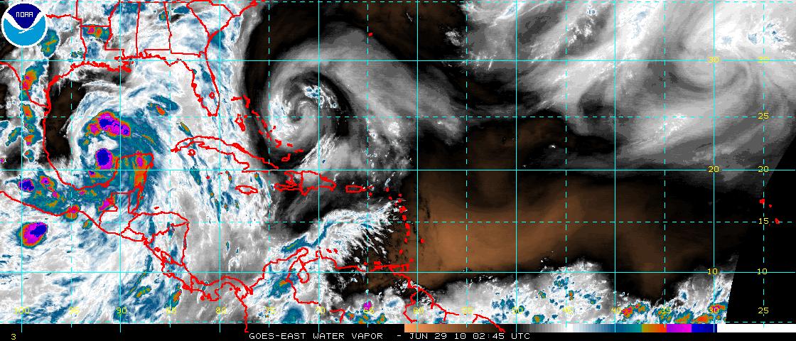
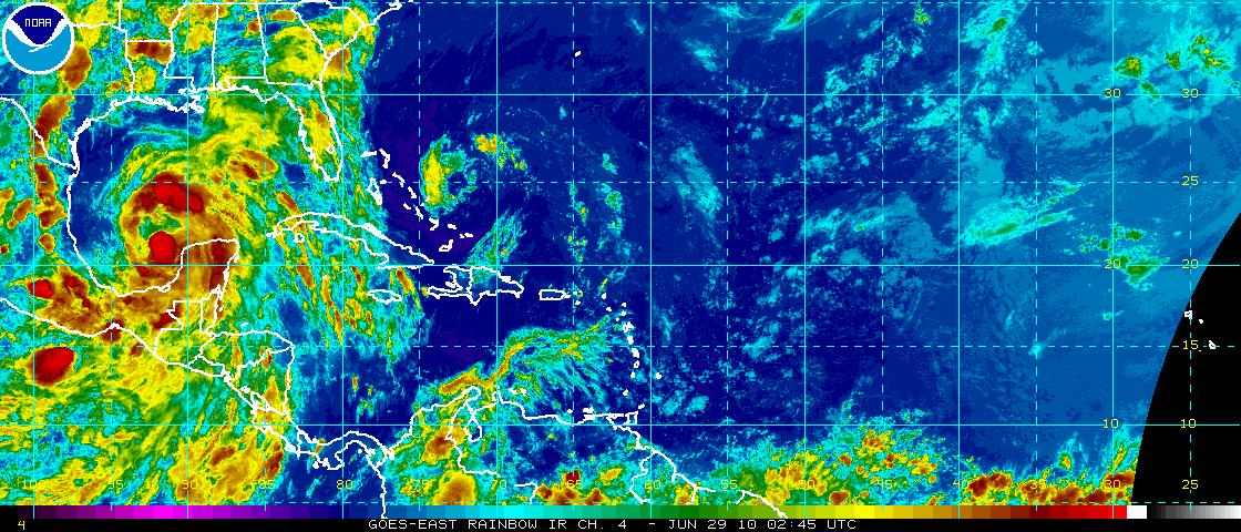
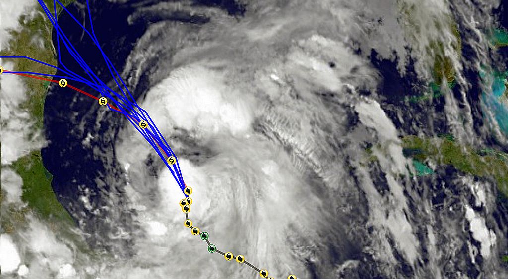
Now for the Eye Candy....what did that say...not a hurricane...YET?

omg...

maybe when it does make land fall, we will see Geraldo take a dive in the Tide surge.
Attachments:

Please Log in or Create an account to join the conversation.

Re:Houston's thread for hurricanes? 14 years 5 months ago #10232

  • houston
  • houston's Avatar Topic Author
  • Offline
  • Gold Boarder
  • Gold Boarder
  • Posts: 698
  • Karma: 28
  • Thank you received: 0
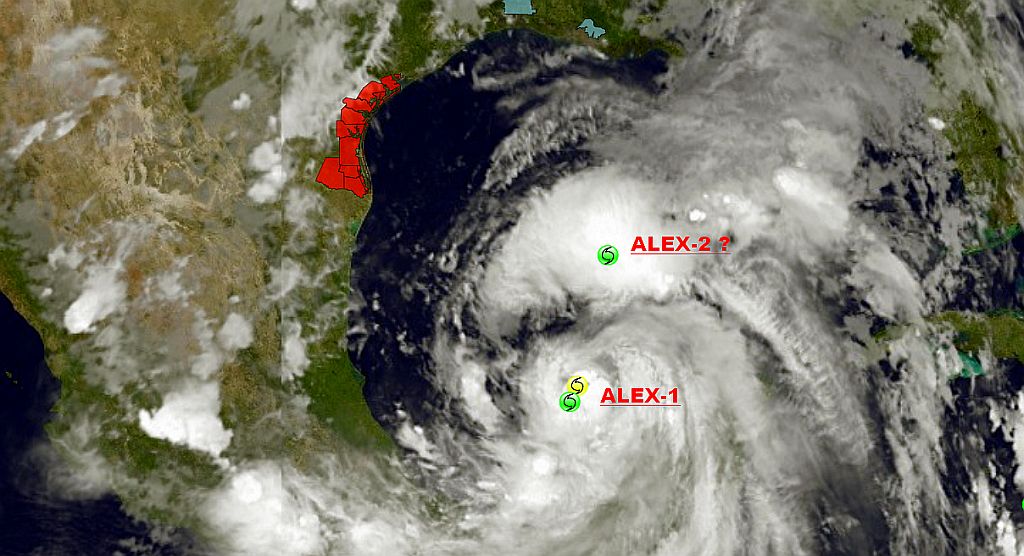
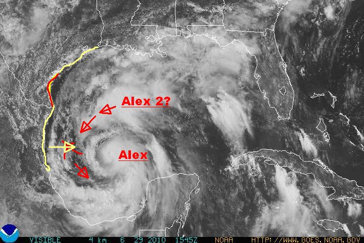
ALEX GIVES BIRTH @ 0341 6-29

This will get real interesting for the Gulf area two systems fighting for the same energy source.
Attachments:

Please Log in or Create an account to join the conversation.

Re:Houston's thread for hurricanes? 14 years 5 months ago #10234

  • MarkS
  • MarkS's Avatar
  • Offline
  • Moderator
  • Moderator
  • Posts: 5348
  • Karma: 118
  • Thank you received: 5
Morning H, you're up early! Watching the news about Alex while checking in here, folks getting ready for the storm along the coast. Rough seas already hindering clean-up operations on the oil spill, not good! This could make an already horrible situation even worse.

Is the storm splitting up like that a good thing? (Maybe weaker than one big one.) I know most people would think two storms would be twice as bad as one, but you 'da man, just wondered.

Please Log in or Create an account to join the conversation.

Mark

Re:Houston's thread for hurricanes? 14 years 5 months ago #10249

  • houston
  • houston's Avatar Topic Author
  • Offline
  • Gold Boarder
  • Gold Boarder
  • Posts: 698
  • Karma: 28
  • Thank you received: 0
well, when I saw this on my Computer...last night...this mourning,

everyone, even me where pretty much assuming that Alex had split...

Now,...that "split" looks as if it will become a "bumper" that will keep him off the South-west shore.

There are currently 50 alerts from Texas to Louisiana, ranging from coastal flooding to actual hurricane warnings from Galveston down to the boarder of Texas.

there is still a chance, Alex will run a bit more north than expected.

MarkS: two is worse than one, when they form they spin around each other.
Attachments:

Please Log in or Create an account to join the conversation.

Re:Houston's thread for hurricanes? 14 years 5 months ago #10251

  • houston
  • houston's Avatar Topic Author
  • Offline
  • Gold Boarder
  • Gold Boarder
  • Posts: 698
  • Karma: 28
  • Thank you received: 0
To answer MarkS question a little better, if you have one system which that was just what Alex was a boarder line Tropical storm around 3:30 am this morning. Sometimes they will brake apart forming two separate systems that then will grow separately but far enough away from each other as to "not interfere with the other as to their growth, but still in the same location. the oddity of this both system can be viewed as one from above because the entire mass is rotating counter clockwise and it looks like one hurricane with two eyes. the down fall is they both fight each other for what ever energy source there is available.

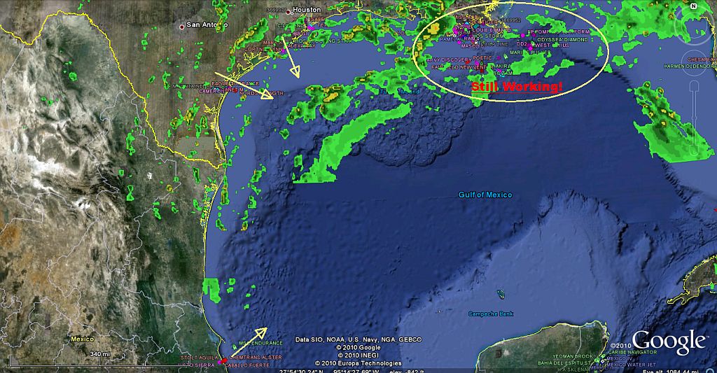
now to see my new toy I have, I now can view maritime sea vessels in real time...so of course I wanted to see what was going on in the gulf.

there looks to be 30 + ships active up around the "leak" at this time, the yellow arrows show boat traffic leaving port to stand off, or in a term to ride the storm out. can't see it here in this picture but the US Navy has a large movement just west of Florida head directly towards the storm, when I zoomed in I saw several "private sail boats" that where 1 to 2 knts, which to me would indicate they where adrift.
Attachments:

Please Log in or Create an account to join the conversation.

Time to create page: 0.369 seconds

Donate

Please consider supporting our efforts.

Glassified Ads

1956 Lonestar Meteor
( / Boats)

1956 Lonestar Meteor
12-24-2024

Mercury outboard
( / Engines)

noimage
11-03-2024

Classic Mercury Outboard Motors
( / Engines)

Classic Mercury Outboard Motors
10-18-2024

FG Login

FiberGoogle

Who's Online

We have 12773 guests and one member online