Welcome, Guest
Username: Password: Remember me
Non Boat Related, Forum for topics not really having anything to do with boats.
  • Page:
  • 1

TOPIC: Tracking The Eye, 2011

Tracking The Eye, 2011 13 years 8 months ago #30353

  • houston
  • houston's Avatar Topic Author
  • Offline
  • Gold Boarder
  • Gold Boarder
  • Posts: 698
  • Karma: 28
  • Thank you received: 0
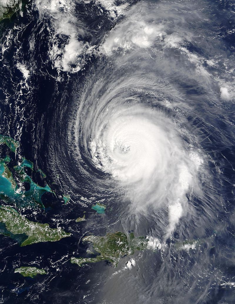
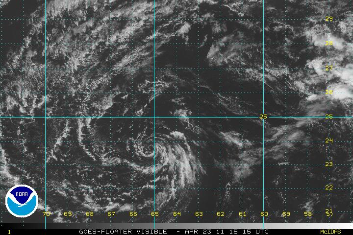
Well, it only late April and yesterday, the NHC started plotting 91-L

91-l is -now- on the grid @ 460 MILES NORTHEAST OF SAN JUAN PUERTO RICO and is heading North West as of now on a course that will bring 91-L 50 miles south of Jacksonville FL.

I personally have issues with the "first storm", but if Florida would end up getting slammed and I would have said nada, well...

I have been watching 91-l for the past couple of days, a couple of days ago it had my full tilt attention, then an upper level shear wind cut off it's head and I said well...oh my, it's dead, the next day NHC calls it an invest with a 40% possibility of growth and now with winds at 40 MPH giving it a 20% chance of becoming a Tropical depression.

if you want to see this, you have to see it as water vapor, the next compounding issue is the storm's crossing out off the lower east 48 may "feed" the growth, the one thing I am curtain of is simple, this should become a late blooming Nor easterner and the east coast should be ready for some relatively heavy rain, if the "spin" builds to give the mass rain cell some Hollywood wind effect, then at the most an extremely early Tropical Depression at the most a tropical storm.

I said extremely early because, the "season" does not begin until June.

should be at the east coast of Florida in 6 to 7 days, if this puppy doesn't stall.

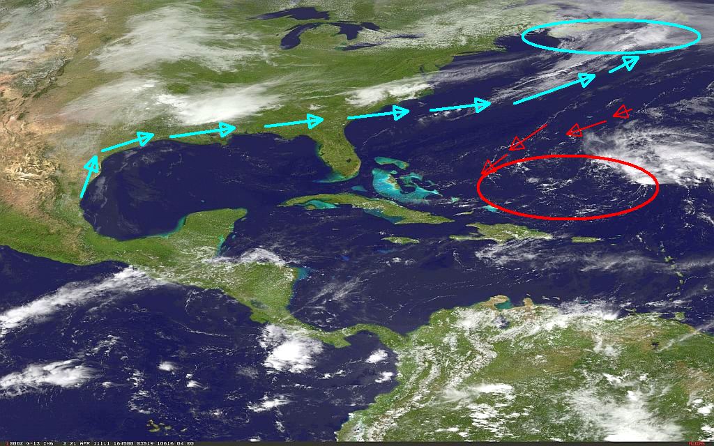
This is what 91-L -was- before it got it's head rip off and took a dive, what it is, right at this moment...is basically invisible, the lower lever circulation is still there but the only "body" you will find is in the look down water vapor satellite's, but like I said before I was looking at this wondering if any one in Miami was even on duty.
Attachments:

Please Log in or Create an account to join the conversation.

Re:Tracking The Eye, 2011 13 years 8 months ago #30363

getting close to that time of year again. glad we have someone informing us to the possibility of bad weather before we are warned on the news. ron

Please Log in or Create an account to join the conversation.

Re:Tracking The Eye, 2011 13 years 8 months ago #30364

  • MarkS
  • MarkS's Avatar
  • Offline
  • Moderator
  • Moderator
  • Posts: 5348
  • Karma: 118
  • Thank you received: 5
On duty - probably. Awake - MAYBE!? (They may be going to the Air Traffic Controller's training course, LOL)

Please Log in or Create an account to join the conversation.

Mark

Re:Tracking The Eye, 2011 13 years 8 months ago #30367

Not to defend the ATC's,my brother has been one for nearly 30yrs in Baton Rouge. I've worked many midnight shifts, in the service, prison and personal protection and it's not easy, No matter how much sleep you get or all the coffee you drink there comes a point during the night when nothing is going on and you can't keep your eyes open no matter what. Changing shifts during the week makes it that much harder. Think of all the car crashes that happen because of fatigue. Just saying it's not that easy. Joe

Please Log in or Create an account to join the conversation.

Re:Tracking The Eye, 2011 13 years 8 months ago #30369

  • MarkS
  • MarkS's Avatar
  • Offline
  • Moderator
  • Moderator
  • Posts: 5348
  • Karma: 118
  • Thank you received: 5
I know, and agree Joe! Most of my career in the Air Force was on "graveyard shift", 11pm to 7AM. It takes it's toll no matter how much sleep you try to get while off duty. Didn't mean to "dis" anybody, sorry! And I couldn't handle the stress in the ATC tower even in my "better days".

Please Log in or Create an account to join the conversation.

Mark

Re:Tracking The Eye, 2011 13 years 8 months ago #30374

  • houston
  • houston's Avatar Topic Author
  • Offline
  • Gold Boarder
  • Gold Boarder
  • Posts: 698
  • Karma: 28
  • Thank you received: 0
joenawlins wrote:

Changing shifts during the week makes it that much harder. Joe


are you saying they are changing "shifts" during the week....omg

Kodak use to do this rapid rotation. it was not "fun"

The one "story" I do know about, two guys same building, same department.

the "father" who was on my rotation his son asked him on morning if it was "alright" to have two daddy's....

seems the other fellow was playing house at his house when one was leaving the other was arriving and he was clueless.

kodak soon ended rapid row because of the high divorce rate and the added "stress" it generated.

Please Log in or Create an account to join the conversation.

Re:Tracking The Eye, 2011 13 years 8 months ago #30376

  • houston
  • houston's Avatar Topic Author
  • Offline
  • Gold Boarder
  • Gold Boarder
  • Posts: 698
  • Karma: 28
  • Thank you received: 0

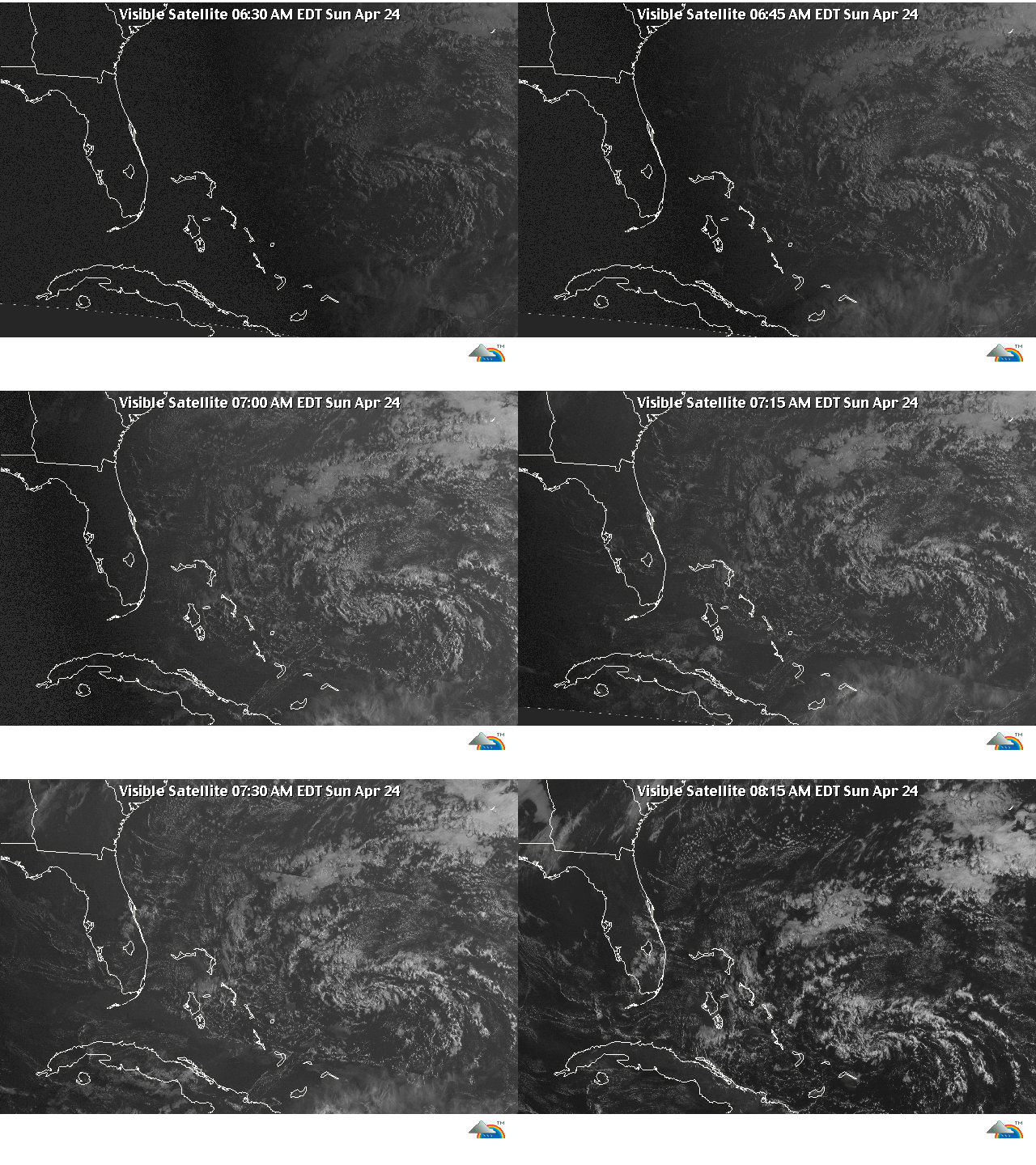
the blue..is the "mess" that was over the lower south east of the 48, it has nicely hauled the mail..out to the north east and will not aid in any rebuilding effort to 91-L.

91-l (red) as shown this mourning, is rather misleading because it "looks empty" where as the water vapor is still there "swirling" but without the cloud "mass", which you can see the remains of what it was to the east.

If 91-L....was pewee Herman, the upper-level shear that he got hit by was Mike Tyson, seriously doubt 91-l will or can recover, but it is "rebuilding" for "round two".

here is a "video" of last years season..very interesting view.

www.nnvl.noaa.gov/MediaDetail.php?MediaID=646&MediaTypeID=2
Attachments:

Please Log in or Create an account to join the conversation.

Re:Tracking The Eye, 2011 13 years 8 months ago #30378

Just keep the back weather off shore. I am going to Fla. in june to do some deepsea fishing. No refunds due to bad weather. It had better be good.

Please Log in or Create an account to join the conversation.

Re:Tracking The Eye, 2011 13 years 8 months ago #30383

wow.........that was entertaining.

Please Log in or Create an account to join the conversation.

Re:Tracking The Eye, 2011 13 years 8 months ago #30422

  • houston
  • houston's Avatar Topic Author
  • Offline
  • Gold Boarder
  • Gold Boarder
  • Posts: 698
  • Karma: 28
  • Thank you received: 0
skipthescrounger wrote:

I am going to Fla. in june to do some deepsea fishing.


Let me think, deep-sea fishing...June...Florida...

Ok, depending on what you want to call "deep" two things your gonna want to take with you.

1. A life Jacket
2. A Rain Coat
3. Sea Sickness pills
4. a web ready satellite IPOD...for you can check in to this thread...

Deep sea fishing in June, one thing your gonna see, well..not actually because of they will be above you is...the wave tops.

Please Log in or Create an account to join the conversation.

Re:Tracking The Eye, 2011 13 years 8 months ago #30463

  • houston
  • houston's Avatar Topic Author
  • Offline
  • Gold Boarder
  • Gold Boarder
  • Posts: 698
  • Karma: 28
  • Thank you received: 0
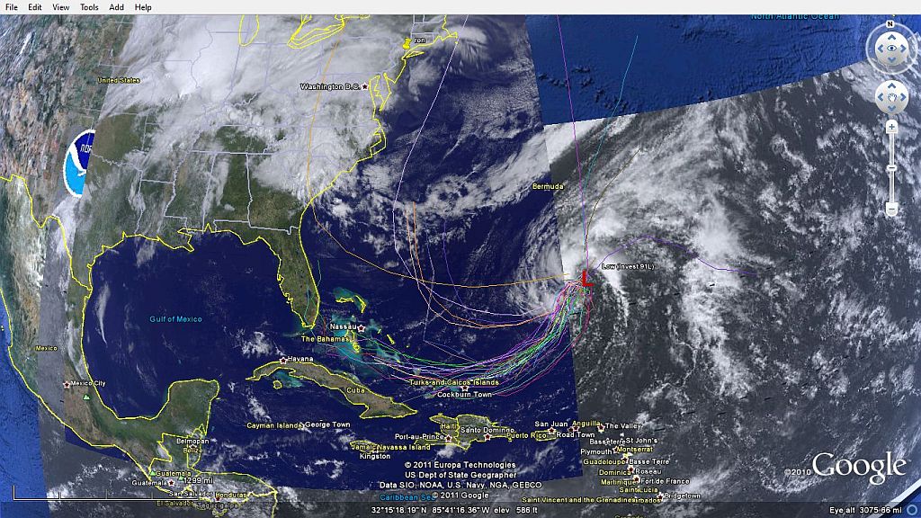
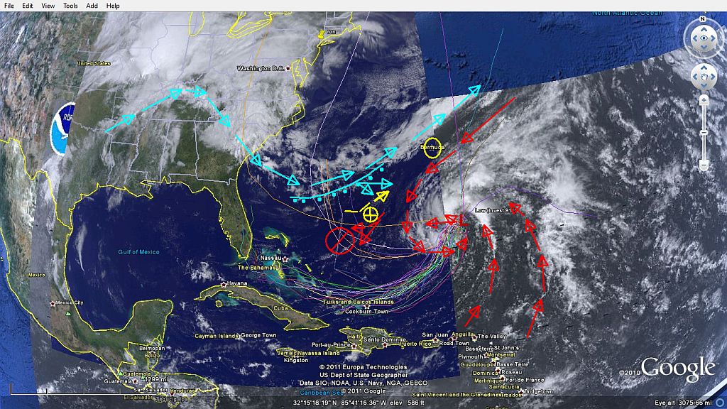
Here is the latest as 91-L get it's grove on...as in picking up his head after the Knock out blow it received, which is still baffling for this time of year

couple of more miles to the west I will be able to pick 91-L up on GOES EAST, which the pictures will be allot better.

This makes me real glad I don't live in Bermuda!

91-L has two things against him and one possible condition in his favor.

Con's
1. it way to early for "it" to be acting this way, but that in it's self may hold a clue.

2. A progressive "Cold" front and 91-L are on a collision course.

Pro's

1. warm water gulf troth is...active again.
2. 48 hours to recover

If an Invest had a brain, or a mind...it would be thinking only of warm water. By the nature of the beast this should steer him to the south west by west. The East passing cold front and 91-L well -tango- each an apposing force will redirect each other but also drop 91-L to it's knees again, how far down depends, this storm has shown it's colors for "recovery"

the odds of this lasting past late tonight (4-22-11) are not in 91-L favor, but taking in consideration the tango will force 91-L down in to warmer waters which would enable a strong and short recovery would be expected. Lets say all the above did happen I would think if the NHC plots per the norm they will count "IT" as dead and when "it" recovers they will rename it 92-L and show it as the ever so dire short POP-UP tropical depression/Storm they have always predicted.

either way, Florida should be expecting rain...how much...depends.

IF 91-L...or (92-L)...get the first name storm, it will be a "she" named "Arlene".....
Attachments:

Please Log in or Create an account to join the conversation.

Re:Tracking The Eye, 2011 13 years 8 months ago #30484

ah...its gunna blow out to sea. oh wait its already there.
Attachments:

Please Log in or Create an account to join the conversation.

Re:Tracking The Eye, 2011 13 years 8 months ago #30531

  • houston
  • houston's Avatar Topic Author
  • Offline
  • Gold Boarder
  • Gold Boarder
  • Posts: 698
  • Karma: 28
  • Thank you received: 0
hehehe...

91-L, is doing exactly what I expected it to do, it -is- encountering the shear again which again knocked -it's- socks off, but this time it has changed track to south by south west @ 10 mph which will put it off the north coast of Puerto-Rico in to warmer water as it collects itself -again-, as I expected it to do.

And...the NHC per the norm has issued a weather bulletin saying that just off the North Coast of Puerto-Rico an -area- of "interest" will develop with in the next 24 hours...which I assume 91-L will get a new desensitization of 92-L....

the way this normally goes, invest get hit with shear they break apart at the upper level, but the lower level -the body- is still there which will recover and when they do recover they get a new desensitization as-if that where that storm "started" which is not entirely true. where they could change the system -just a little- where when a system has become an actual "invest" that it takes on a designator of the phonic spelling of the alphabet (alfa, bravo charily) where this invest would be called Alpha-3 by the time it gets to Puerto-Rico because it would have rebuilt it self 3 times and is the first invest.

as everyone knows, the way the story goes, an area will get hit and that county will say "well we didn't have much warning" and they blame the state, the state in turn tells the county that it also didn't have much warning and blame the federal government then in turns says that they didn't have much warning either and couldn't say exactly where the system was "heading".....which just isn't entirely true.

Please Log in or Create an account to join the conversation.

Re:Tracking The Eye, 2011 13 years 8 months ago #30536

  • houston
  • houston's Avatar Topic Author
  • Offline
  • Gold Boarder
  • Gold Boarder
  • Posts: 698
  • Karma: 28
  • Thank you received: 0
For those that use Google Earth, you may find the old "weather bundle" has been set to the side and much of what is in the "package" no longer works.

They are now using a new "bundle" it seems that does -more-

what I been doing is picking apart the old bundle of stuff that still works and adding it to the new bundle of the new gear, which you can do by simply "click-Drag-place" from the old to the new.

here is a link and contents of the new bundle, which even if you don't want to "follow" hurricanes, you can zoom in to your city,state and see what happen about the same time your local weather guy is trying to figure it out also.


www.atmos.illinois.edu/web/google_earth_contents.shtml

GET IT HERE


:DAS GOOGLE EARTH WEATHER BUNDLE :

>Google Earth Web Bundle< (kmz file)

Surface:
Surface Analysis (courtesy the National Weather Service: www.srh.noaa.gov/gis/kml/cod/susLink.kml
METAR Observations (courtesy the National Weather Service: www.srh.noaa.gov/gis/kml/metar/metarlink.kml
Sea Surface Temperature in °C (TMI + AMSR-E) (data courtesy Remote Sensing Systems: www.ssmi-data.com/sst/microwave_oi_sst_browse.html )
Sea Ice Concentration (data courtesy Polar Research Group at UIUC: arctic.atmos.uiuc.edu/cryosphere/ )
CoCoRaHS Precipitation (courtesy the National Weather Service: www.srh.noaa.gov/gis/kml/cocorahs/cocorahsLink.kml
AHPS Flood Gauges (Data courtesy NWS AHPS: www.weather.gov/ahps/download.php )
Weekly Drought Monitor (courtesy the National Integrated Drought Information System: www.drought.gov )
Daily Snow Cover, Snow Water Equivalent, and Snow Depth (courtesy NOHRSC: www.nohrsc.noaa.gov/earth/ )
Daily SNOTEL Station data (courtesy NRCS: www.wcc.nrcs.usda.gov/snotel/earth/index.html )

SPC and NWS Convective Watches and Warnings:
Tornado Watches and Warnings (courtesy Warning Decision Support System: www.wdssii.org/ )
Severe Thunderstorm Watches and Warnings (courtesy Warning Decision Support System: www.wdssii.org/ )
Flash Flood Warnings (courtesy Warning Decision Support System: www.wdssii.org/ )
Special Marine Warnings (courtesy Warning Decision Support System: www.wdssii.org/ )
Mesoscale Discussions (courtesy Warning Decision Support System: www.wdssii.org/ )
SPC Day 1 - 8 Outlooks (data courtesy the Storm Prediction Center [SPC]: www.spc.noaa.gov )
SPC Day 1 Probabilistic Outlooks (Tornado, Hail, Wind) (data courtesy the Storm Prediction Center [SPC]: www.spc.noaa.gov )
SPC Discussions (data courtesy the Storm Prediction Center [SPC]: www.spc.noaa.gov )
SPC Current Day's Storm Reports (courtesy Warning Decision Support System: www.wdssii.org/ )

AVO Volcano Alerts
Volcano and aviation advisories, watches and warnings (courtesy Alaska Volcano Observatory: www.avo.alaska.edu/
Volcano Webcams (courtesy Alaska Volcano Observatory: www.avo.alaska.edu/

Soundings:
College of DuPage (COD) North American Skew-T Log P diagrams (courtesy College of DuPage: weather.cod.edu/analysis/analysis.sound.html )
COD North American Stuve Diagrams (courtesy College of DuPage: weather.cod.edu/analysis/analysis.sound.html )

Radar:
Regional Radar Reflectivity Animations (including Conterminous US, Alaska, Hawaii, and Puerto Rico) (courtesy the National Weather Service: www.srh.noaa.gov/ridge/kmzgenerator.php )

Satellite:
CONUS Visible Satellite Animation (courtesy Warning Decision Support System: www.wdssii.org/ )

CONUS Infrared Satellite Animation (courtesy Warning Decision Support System: www.wdssii.org/ )

CONUS Water Vapor Satellite Animation (courtesy Warning Decision Support System: www.wdssii.org/ )

Global AVHRR Latest Imagery (courtesy CIMSS/SSEC: www.ssec.wisc.edu/google-earth/ )

Hurricanes:
Current Atlantc, Eastern Pacific, and Central Pacific hurricane tracks with forecast locations and discussions (data courtesy of the National Hurricane Center: www.nhc.noaa.gov )

Most Recent Hurricane Hunter Flight Tracks and Data (courtesy of www.tropicalatlantic.com )

Model Spaghetti Plots for Current Atlantic Cyclones (courtesy of www.tropicalatlantic.com )

Hurricane Watch and Warning Breakpoints (updated 2008; data courtesy of the National hurricane Center www.nhc.noaa.gov )

Great Lakes Data:
Great Lakes Nowcasts (wind speed, wave height, temperature, currents, and ice concentrations) (courtesy Great Lakes Environmental Research Laboratory: www.glerl.noaa.gov/res/glcfs/ )

Ocean Data:
Atlantic Buoy Data (courtesy Paul Seabury: www.paulseabury.com )

Sea Surface Temperature in °C (TMI + AMSR-E) (data courtesy Remote Sensing Systems: www.ssmi-data.com/sst/microwave_oi_sst_browse.html )

Sea Ice Concentration (data courtesy Polar Research Group at UIUC: arctic.atmos.uiuc.edu/cryosphere/ )

Real-time World Tide Predictions (data courtesy University of Udine, Italy www.fisica.uniud.it )

Global Bathymetry Data (courtesy National Geophysical Data Center: www.ngdc.noaa.gov/mgg/image/2minrelief.html )

Fire Weather:

Current CONUS, Alaska, Hawai'i, and Canada wildfires observed from MODIS (courtesy USDA Forest Service, Remote Sensing Applications Center: activefiremaps.fs.fed.us/ )

Day 1-8 Fire Weather Outlooks (data courtesy the Storm Prediction Center: www.spc.noaa.gov )

Categorized Fire Weather Observations (courtesy the National Weather Service: www.srh.noaa.gov/gis/kml/raws/firewxlink.kml )

Air Quality Index:
Air Quality Index (Current and Forecast) (courtesy AirNow: airnow.gov )


Historical Events

Imagery from the Great Flood of 1993 (courtesy Scientific Visualization Studio: svs.gsfc.nasa.gov/ )

Historical Global Temperature Record for all surface stations available (coutresy EdGCM: edgcm.columbia.edu/ )

Historical Tropical Cyclone Tracks for the Atlantic Ocean (1851-2007), Eastern Pacific Ocean (1949-2007), Western Pacific Ocean (1949-2007), Indian Ocean (1945-2007), and Southern Hemispheric Ocean (1949-2007) (data courtesy the National Hurricane Center: www.nhc.noaa.gov/pastall.shtml and the Joint Typhoon Warning Center: metocph.nmci.navy.mil/jtwc.php )

Tropical Storm Allison Satellite Imagery (courtesy Scientific Visualization Studio: svs.gsfc.nasa.gov/ )

Hurricane Katrina Flooding: MODIS and Aerial Imagery (courtesy Google Earth Library: www.gelib.com/maps/Katrina/Katrina.kml ?)

1997-1998 El Nino SST Anomalies, Sea Surface Height Anomalies, and Wind Anomalies (courtesy Scientific Visualization Studio: svs.gsfc.nasa.gov/ )

Please Log in or Create an account to join the conversation.

Re:Tracking The Eye, 2011 13 years 8 months ago #30600

  • houston
  • houston's Avatar Topic Author
  • Offline
  • Gold Boarder
  • Gold Boarder
  • Posts: 698
  • Karma: 28
  • Thank you received: 0
Well ron, if you really look at it...

it not "blowing-out-to-sea", much rather it blowing into shore from the wrong direction...all trackers have taking 91-L off the grids, well except for one, now the NCH is giving this a 30% of rebuilding as "if" it is a new system.

there are really 3 parts to an invest Low level winds, mid level and upper, the shear just rips off the upper level leaving the lower and the mid to continue-on, what I refer to as a "ghost" because sometimes you only can see it in the "water-vapor" imaginary.

what remains of 91-L..well rebuild but not by much and head up over Florida from the south to the north probably as a subtropical.

any one using GE and the new weather bundle? why would the NAVY website be have technical problems for-days? it almost like they have gone off-line.
Attachments:

Please Log in or Create an account to join the conversation.

Re:Tracking The Eye, 2011 13 years 8 months ago #30642

  • houston
  • houston's Avatar Topic Author
  • Offline
  • Gold Boarder
  • Gold Boarder
  • Posts: 698
  • Karma: 28
  • Thank you received: 0
well, here a little thing that came over the ticker tonight, happy Easter-btw

.SYNOPSIS...TROUGH FROM 26N71W TO 20N72W. LOW DISSIPATES TONIGHT
AND TROUGH WILL MOVE W THROUGH THE BAHAMAS THROUGH MON NIGHT THEN
DISSIPATE OVER FLORIDA TUE. A COLD FRONT MOVES OFF THE NE FLORIDA
COAST THU EVENING
...AND WILL EXTEND FROM 31N74W TO N BAHAMAS FRI.

SEAS GIVEN AS SIGNIFICANT WAVE HEIGHT...WHICH IS THE AVERAGE
HEIGHT OF THE HIGHEST 1/3 OF THE WAVES
. INDIVIDUAL WAVES MAY BE
MORE THAN TWICE THE SIGNIFICANT WAVE HEIGHT
.

.TONIGHT...NE TO E WINDS 10 TO 15 KT. SEAS 5 TO 6 FT.
.MON THROUGH TUE...N OF 10N E WINDS 15 TO 20 KT. SEAS 7 TO 9 FT
IN E SWELL. S OF 10N NE TO E WINDS 10 TO 15 KT. SEAS 5 TO 7 FT.
.TUE NIGHT THROUGH THU...N OF 14N E WINDS 20 KT. SEAS 8 TO 10 FT
IN E SWELL. S OF 14N E WINDS 15 TO 20 KT. SEAS 7 TO 8 FT.
.FRI...E WINDS 15 KT. SEAS 6 TO 7 FT.

$$
AMZ080-250330-
SW N ATLANTIC S OF 31N W OF 65W INCLUDING BAHAMAS
530 PM EDT SUN APR 24 2011

well just going by a general thumb nail low 9 ft - 15 ft to a max of 20 foot waves....all week M-F.

Please Log in or Create an account to join the conversation.

Re:Tracking The Eye, 2011 13 years 8 months ago #30655

So whats it going to be like in the middle of june. I really dont like fishing in a tropical storm.

Please Log in or Create an account to join the conversation.

Re:Tracking The Eye, 2011 13 years 8 months ago #30674

  • houston
  • houston's Avatar Topic Author
  • Offline
  • Gold Boarder
  • Gold Boarder
  • Posts: 698
  • Karma: 28
  • Thank you received: 0
June in Florida really depends where you would be, to the west in the gulf or to the east out in the Atlantic?

most tracks in June seem to run "early" in to the S/W pocket of the Gulf, or up and around between Cuba and south tip of Florida.

The only exception was way back when these people where taking a three hour tour...

Please Log in or Create an account to join the conversation.

Re:Tracking The Eye, 2011 13 years 8 months ago #30691

  • houston
  • houston's Avatar Topic Author
  • Offline
  • Gold Boarder
  • Gold Boarder
  • Posts: 698
  • Karma: 28
  • Thank you received: 0
skipthescrounger wrote:

So whats it going to be like in the middle of june. I really dont like fishing in a tropical storm.


here a quick way to check, as some good focal points "some what" like GE and a little bit of the crazy stuff I can turn on

INTERACTIVE weather map

Please Log in or Create an account to join the conversation.

Re:Tracking The Eye, 2011 13 years 7 months ago #31243

  • houston
  • houston's Avatar Topic Author
  • Offline
  • Gold Boarder
  • Gold Boarder
  • Posts: 698
  • Karma: 28
  • Thank you received: 0
been meaning to bring this up to date for a bit, but the recent activity's really -side- line everything.

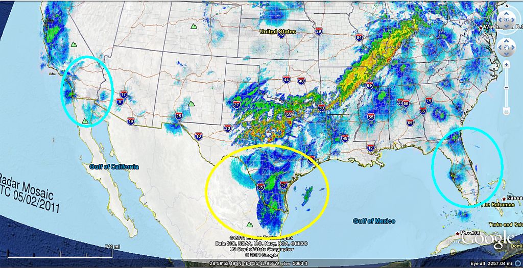
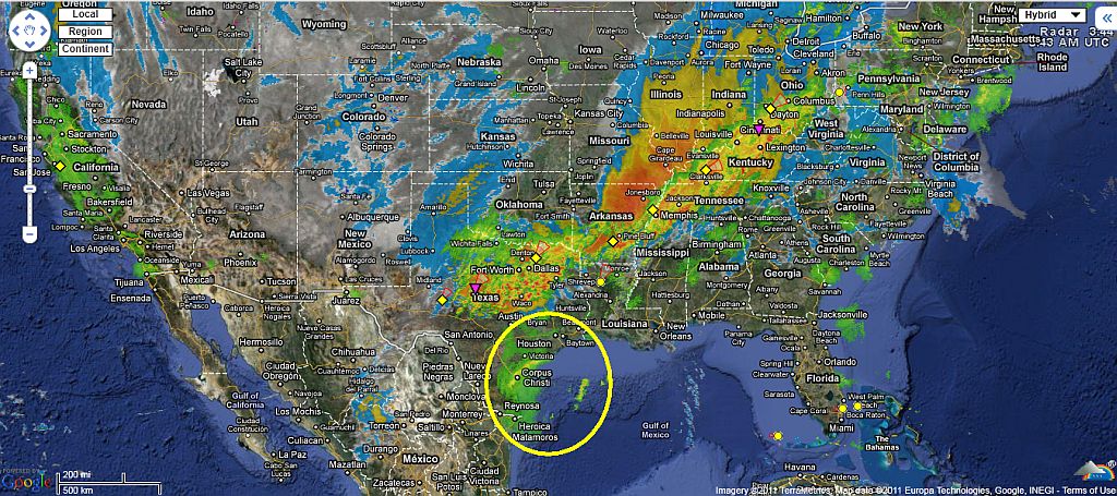
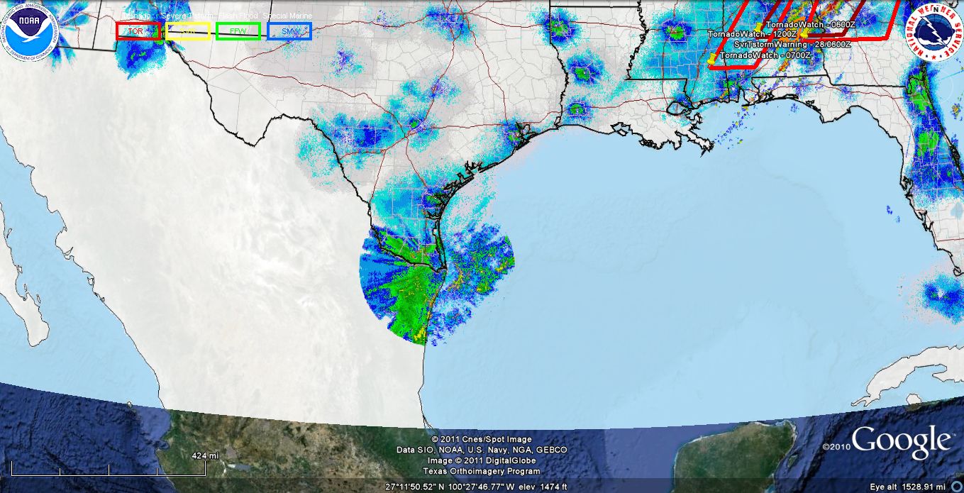
three days ago, we where put under a tornado -warning-, two days before that I picked up some "rather" weird stuff on the national radar, which I explained to genny that there is this storm just east of mid central that seems to be building from "nothing", which now what the nothing was that was being pick up on the radars was smoke from a vast prairie fire in northern Mexico and southwest Texas.

the day after the tornadoes I again started picking up the same odd reflection in the radars in Texas that they where "showing" something where there was nothing to see, no clouds, or moisture.

this screen shot was when blob that was over mid central was just done building, and took a direct broad side on it's west side and literally flatten towards the north east to the gulf of mexico and started being forced to the east which the remains of 91 L was still lingering also.

---so the rest is as they say history--

I hope everyone stayed safe and all is well.

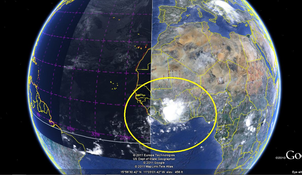
this mourn is 5/3, and my "stuff" pickup a system moving to the west, coming of the coast of Africa, should be here just when the season starts in June.

this should give it a nice four week travel time.
Attachments:

Please Log in or Create an account to join the conversation.

Re:Tracking The Eye, 2011 13 years 7 months ago #31340

  • houston
  • houston's Avatar Topic Author
  • Offline
  • Gold Boarder
  • Gold Boarder
  • Posts: 698
  • Karma: 28
  • Thank you received: 0

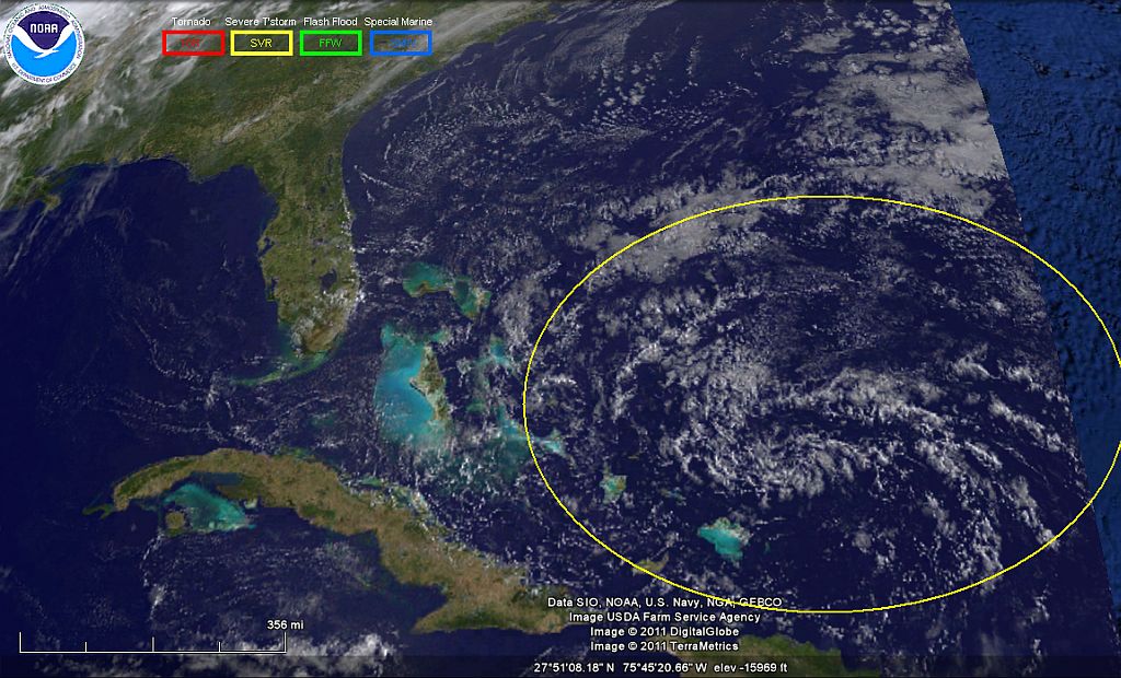
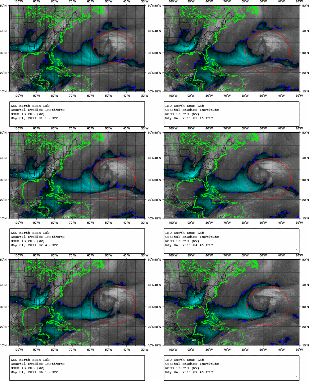
note the swirling off the east coast, this is the remains of the "big-one", I been watching it basically stay in this location but steady dropping to the south. the system that I am also following off the coast of Africa went to sea in "grand fashion" and is currently heading for the north tip of south America, what if anything will these two system do when they interact has not been covered in amongst the "experts".
Attachments:

Please Log in or Create an account to join the conversation.

Re:Tracking The Eye, 2011 13 years 7 months ago #31599

  • houston
  • houston's Avatar Topic Author
  • Offline
  • Gold Boarder
  • Gold Boarder
  • Posts: 698
  • Karma: 28
  • Thank you received: 0
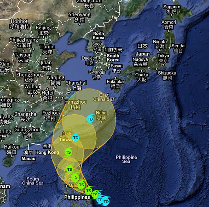
like these people haven't got enough going on...Gezzzz

so the north side of japan from from just north of Tokyo up to the north east tip has pretty well been as I term it "Dusted", and now the government is ordering three more power station to -shut down- and the head chief of staff that handles the nuclear power "issues" just up and quit.

Not to mention the Playstation 3 issues with the users files being stolen, like really folks they got even -MORE- problems now, like I said the season is changing and it just changed for japan in a -bad way-

so everyone who has left the North East side and has taken shelter on the Southwest side, are now looking down the barrel Of at the moment a tropical depression head at them, and that not even mention they are living at the base of a couple of active volcanoes also.

up here where I am, it's 60 something...and you know what it could snow right this minute and I would truly enjoy it because i think it could be allot worse.
Attachments:

Please Log in or Create an account to join the conversation.

  • Page:
  • 1
Time to create page: 0.283 seconds

Donate

Please consider supporting our efforts.

Glassified Ads

1956 Lonestar Meteor
( / Boats)
1956 Lonestar Meteor
12-24-2024

Mercury outboard
( / Engines)

noimage
11-03-2024

Classic Mercury Outboard Motors
( / Engines)

Classic Mercury Outboard Motors
10-18-2024

FG Login

FiberGoogle

Who's Online

We have 13955 guests and one member online